
Generate a .gpx-file with campings as waypoints near your track.
 If you're a user of simple but sturdy GPS-devices like the Etrex 20x, enjoy being off grid or don't have a smartphone ... this tool might be interesting.
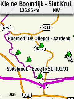
It takes a GPX-track file as input and returns a GPX-waypoints file with 'campings' near your tracks. These campings will show up as little tents on the map of your GPS (see image). When feeling tired, just zoom out a bit and ride to the nearest tent and get some sleep.
Theoretically you could use a really big waypoints file with all campings but then a lot of the GPS devices will slow down or not even load all waypoints. With this tool, you make a selection of only the campings you will get near.
After uploading your GPX-track and downloading the generated waypoints-GPX, just put both files on your device. In contrast to the GPX-track, you don't have to 'load' the waypoint file on the device. The camping waypoints will always appear.
If you open the waypoint/camping in your device in the description you will see the phone number and/or e-mail address if available.
All campings from the Open Street Maps are used except the campings that have the tags access=private or nudism=['yes','obligatory','designated','customary']
Created by megasnort.com with Open Street Map data of 17-11-2025 .